26 Nov 2025
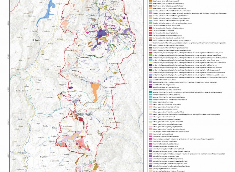
Map of Land Use Change according to CLC 2000–2018
The Map of Land Use Change according to CLC 2000–2018 presents the evolution of land cover in the territory of the "Korab–Koritnik" Nature Park during an 18-year period, based on the CORINE Land Cover classification. It identifies transitions from one land use category to another, such as from deciduous forest to natural grasslands, from agricultural land to areas with natural vegetation, or from grasslands to areas with transitional shrub vegetation. The map highlights both gains and losses in area for different categories, reflecting ecological dynamics and the impact of natural and anthropogenic factors.
The most significant changes are related to the transformation of agricultural lands and the expansion of natural vegetation in some areas, suggesting abandonment of traditional activities or natural regeneration. Transitions are also observed between broad-leaved forests, mixed forests and grasslands, indicating natural succession processes or management interventions. The map includes reference elements such as administrative boundaries, road network, hydrography and contour lines, allowing for detailed spatial analysis.
This document serves as an important tool for assessing environmental trends, territorial planning and monitoring impacts on habitats of conservation interest. In the context of protected area management, it helps identify areas requiring restoration measures or control of human pressures, as well as in supporting policies for sustainable land use.
To enable graphic visualization, click on the link below: https://drive.google.com/file/d/1da1F_68dDUOdgCsXS6Ccgy-NTJw6x4al/view?usp=sharing